
Buchanan County, Iowa Land Records
Buchanan County, Iowa Land Records
Buchanan County, Iowa Land Records
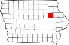
Buchanan County, Iowa is located in Northeast Iowa covering 571 square miles. There are 1,075 farms in Buchanan County, Iowa consisting of 336,863 acres farmland. 303,756 of the 336,863 farmland acres are used for cropland. In 2012 crops total sales came to $247,096,000 making up 63% of the harvest value. Also in 2012, livestock total sales came to $143,625,000 making up 37% of the harvest value. The government paid an average of $13,393 per farm in 2012. The average size of a farm in Buchanan County, Iowa is 318 acres. Farmland value in Buchanan County sits at $$7,913 per farmland acre. Thigh highest known farmland to sell was in December 2012 for $18,304 per acre. Also with that the highest CSR sale in the county was 51.9 acres at $949,977.60.
Buchanan County, Iowa Land Records Rent
Buchanan County, Iowa Land Records states that the average rent in Buchanan County is $254 per farmland acre. This number ranges from $150 per acre to $$330 per acre, the average rend in Northeast Iowa is $250 per acre. Rent per CRS Point is $3.10 per CSR2. Improved pasture can be rented for $90 per acre at regional average, while unimproved pasture can be rented for $53 per acre at regional average.
Buchanan County, Iowa Townships and History
Buchanan County, Iowa is made up of the following towns: Aurora, Independence, Rowley, Brandon, Jesup, Stanley, Fairbank, Lamont, Winthrop, Hazelton, and Quasqueton. Buchanan County, Iowa was created on December 21, 1837 and was named in honor. of Senator James Buchanan the 15th President of the United States. There is a population of 20,958 people with a density of 37 people per square mile.